


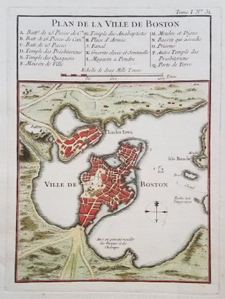
Plan de la ville de Boston.
[Paris.]: from Petite Atlas Maritime. [1764.]. 8 ½ x 6” plus margins. A classic map of Boston and the immediately surrounding area from near the end of the French & Indian War. The map appeared in Bellin’s Petit Atlas Maritime in 1764. A 16-item legend above the map identifies various..... More


![Item #3743 Vue de Salem. [subtitle:] Eine Stadt im Engellaendischen America, in der Grafschafft...](https://bickerstaffs.cdn.bibliopolis.com/pictures/3743.jpg?width=320&height=427&fit=bounds&auto=webp&v=1637446983)