


![Item #3716 [The Harbours and Rivers between Portland Point and Stage Island.]. Maine: Casco Bay., Joseph Frederick Wallet Des Barres.](https://bickerstaffs.cdn.bibliopolis.com/pictures/3716.jpg?width=768&height=1000&fit=bounds&auto=webp&v=1600611985)
![[The Harbours and Rivers between Portland Point and Stage Island.]](https://bickerstaffs.cdn.bibliopolis.com/pictures/3716_2.jpg?auto=webp&v=1600611985)
![[The Harbours and Rivers between Portland Point and Stage Island.]](https://bickerstaffs.cdn.bibliopolis.com/pictures/3716_3.jpg?auto=webp&v=1600611985)
![[The Harbours and Rivers between Portland Point and Stage Island.]](https://bickerstaffs.cdn.bibliopolis.com/pictures/3716_4.jpg?auto=webp&v=1600611985)
![[The Harbours and Rivers between Portland Point and Stage Island.]](https://bickerstaffs.cdn.bibliopolis.com/pictures/3716_5.jpg?auto=webp&v=1600611985)
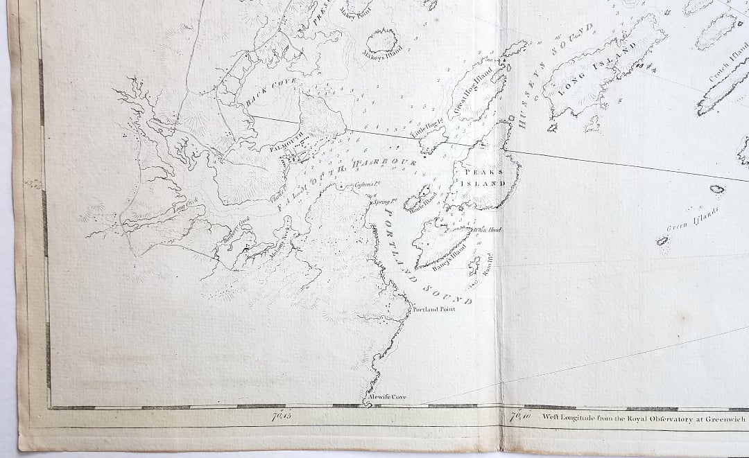
[The Harbours and Rivers between Portland Point and Stage Island.]
London: From The Atlantic Neptune. Circa 1776. The chart was folded into four vertical panels (about 30 1/4 x 12") to accommodate being "bound up in tall narrow form" (Stevens' Catalogue, p. vii.) The chart paper has the LVG watermark, consistent with the earlier issues of the chart. Two sheets, joined; overall image area: approximately 29 1/2 x 42. A wonderfully clean example of a striking chart of Casco Bay. Item #3716
This is an exceptional chart of the coast of Maine between Cape Elizabeth and Popham from the early Revolutionary War period. It is from Des Barres' monumental Atlantic Neptune, a sea atlas published by the British Admiralty during the last quarter of the 18th century. The Atlantic Neptune has been called "the most splendid collection of charts, plans, and views, ever published."
The present chart includes all of Casco Bay (naming the larger islands) and extends east to include Seguin ("Segevin Island") and Georgetown Islands. Among the numerous geographic features named are Great Jebieg (Chebeague), Merrymeeting Bay, Segadahock River, Arrowsick Island and Halfway Road (i.e., Rock). Roads are shown on the chart, as are individual buildings.
The chart is dated July___ 1776 (i.e., with a prominent space after the month as if a date were going to be inserted). There is no type-stamped "15" at the upper right as called for in some copies of state "b" of the Stevens Catalogue.
A scarce, early state of a desirable chart. Stevens, Catalogue of the Atlantic Neptune: 105, State: b. Sellers & Van Ee, Maps and Charts of North America and the West Indies, 1750-1789: 855. [ICN 3763.].
Price: $7,950.00