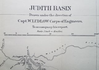
Judith Basin: Drawn under the direction of Capt. W. Ludlow Corps of Engineers.
[Washington, DC.]: [Government Printing Office.], 1876. 17 ¼ x 12.”. This map provides detail of the Judith Basin area included in Capt. William Ludlow’s map from Carroll, Montana to Yellowstone Park in the summer of 1875. The map identifies Judith River, Judith Mountains, Snowy Mountains and Fort Clagett..... More