


![Item #3766 Map of the Brockton & Plymouth Street Railway. [frontis of] By Trolley Inland and Alongshore to Plymouth. Massachusetts: Plymouth County., Geo H. Walker, Co.](https://bickerstaffs.cdn.bibliopolis.com/pictures/3766.jpg?width=768&height=1000&fit=bounds&auto=webp&v=1668299703)
![Map of the Brockton & Plymouth Street Railway. [frontis of] By Trolley Inland and Alongshore to Plymouth.](https://bickerstaffs.cdn.bibliopolis.com/pictures/3766_2.jpg?auto=webp&v=1668299703)
![Map of the Brockton & Plymouth Street Railway. [frontis of] By Trolley Inland and Alongshore to Plymouth.](https://bickerstaffs.cdn.bibliopolis.com/pictures/3766_3.jpg?auto=webp&v=1668299703)
![Map of the Brockton & Plymouth Street Railway. [frontis of] By Trolley Inland and Alongshore to Plymouth.](https://bickerstaffs.cdn.bibliopolis.com/pictures/3766_4.jpg?auto=webp&v=1668299703)
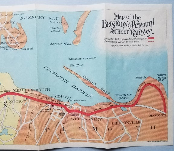
Map of the Brockton & Plymouth Street Railway. [frontis of] By Trolley Inland and Alongshore to Plymouth.
Boston: Geo. H. Walker & Co., Copyright 1901. Printed cardboard wrappers. 26 pp. plus five unnumbered leaves of advertisements. 6 ¼ x 3 ¼.” Folding colored lithographic map. Image size of map: 5 ½ x 22 ½.” The back of the map has moderate darkening along one fold, a spot of foxing, a small area of print transfer from the first page of the text and initials and a number in ballpoint pen. Despite these minor flaws, the map displays very nicely. Front and back wrappers of the pamphlet have a vertical imperfection of uncertain origin. The text block is somewhat wavy as if the pamphlet had been in a high-humidity environment. Some darkening to edges. Item #3766
This very colorful map of the route of the Brockton & Plymouth Street Railway is a wonderful feature of the guidebook that highlights many of the historic attractions of Duxbury, Kingston and Plymouth. The route of the street railway ran from Manomet in Plymouth northwestward through Kingston, Pembroke, Hanson and Whitman to Brockton. Included is a list of hotels, prominent buildings and places in Plymouth, as well as ten pages of advertisements by local businesses.
An uncommon map and guide. OCLC identifies two holders of the map (BPL and Harvard) and two of the pamphlet (Harvard and University of Delaware)
[ICN 7615.1.].
Price: $150.00